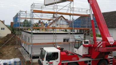
Real Tips

The Ultimate Guide to Survey Plans You Must Know

Introduction

Survey plans are one of the most essential documents in real estate, but many people don’t fully understand them. A survey plan tells you exactly what you’re getting if you’re buying land, building a home, or investing in property. It shows your land’s boundaries, size, shape, and legal limits.

Still, most people skip this vital step or rely on unverified plans. In this guide, I’ll walk you through everything you need to know about survey plans, as clearly and simply as I can.

By the end, you’ll know how to read a survey plan, why it matters, and how to avoid costly mistakes when using one.

What Is a Survey Plan?

A survey plan is a detailed drawing that shows the exact boundaries and measurements of a specific piece of land. A licensed surveyor typically creates it using professional tools like DGPS, Total-station, Theodolites, and measuring tapes.

Here’s what a typical survey plan includes:

  • Property boundaries (with exact lengths and angles)
  • Beacons or corner points
  • The land’s orientation (with a compass direction)
  • Neighbouring plots or roads
  • Surveyor’s name, license number, and signature
  • Date of the survey
  • Surveyor’s seal

In short, it’s a legal document that proves the existence and layout of your land.

Why Are Survey Plans Important?

Survey plans are more than just maps— they’re protection. If you skip this step, you could end up:

  • Buying the wrong plot
  • Building outside your land
  • Facing legal disputes with neighbours or even the government
  • Losing money in court

Let’s explore the main benefits of having a valid survey plan:

1. Confirms Land Ownership

A survey plan shows that the land exists in the right location and matches the land records. This can be used to support your deed of assignment, certificate of occupancy, or any land title.

 2. Helps You Avoid Disputes

Many land-related arguments arise from unclear boundaries. A survey plan shows where your land starts and ends. This clarity helps prevent or resolve boundary disputes.

3. Guides Your Building Projects

Before you build a house, fence, or even drill a borehole, your survey plan tells you where and how to place these structures. You can share it with architects, engineers, or town planners.

4. Essential for Government Documentation

If you plan to register your land or apply for a title document like a C of O, you must submit a registered survey plan. You must include it; otherwise, the authorities will reject your application.

Types of Survey Plans You Should Know

Different types of survey plans serve different purposes. Here are the common ones:

1. Preliminary Survey Plan

A licensed surveyor creates this rough sketch, known as a Provisional Survey Plan, to provide an overview of a land area before complete documentation. Professionals use it for initial property discussions, family agreements, land sharing, or early-stage transactions. The surveyor typically includes the letter “P” in the plan number and may label it “Provisional Copy”.

An example of a Provisional Survey Plan

 2. Registered Survey Plan

This is a PERIMETER SURVEY carried out with its RECORD COPY officially lodged with the state Office of Surveyor-General. This type of survey usually has pillar numberings in the form “SC/OG” for surveys within Ogun state and “SC/LA” for Lagos state, etc. The surveyor who carried out the survey must duly sign and seal the registered survey plan. Also, the pillar numberings for a government allocation usually carry the prefix PB.

3. Topographic Survey plan

This shows both the natural and man-made features on the land like trees, contours, buildings, etc. They are majorly used for engineering designs.  

How to Read a Survey Plan (Step-by-Step)

If you’ve ever looked at a survey plan and felt confused, you’re not alone. But once you understand the basic parts, it gets easier. Here’s how to read one:

1. Locate the Title Block

This is usually found at the bottom of the plan. It contains key details like:

  • Surveyor’s name
  • Date of the survey
  • Surveyor’s signature and Seal
  • Plan number

 2. Check the Boundary Lines

These are thick, red lines that show the exact perimeter of the land. The surveyor labels each side with a distance (in meters or feet) and a bearing.

 3. Find the North Arrow

This shows the direction the land is facing. It helps you understand the land’s orientation in real life.

 4. Identify Beacons

Beacons are physical markers placed at the corners of the land. On the plan, they are often marked as “SC/OG AX1234BD,” “PB423,” etc.

 5. Look for Official Approval

If your survey plan is registered, it will have a beacon prefix in the form “SC/OG AX1234BD”, the surveyor’s seal and signature, and a plan number. Always confirm this before accepting any plan.

When Do You Need a Survey Plan?

You’ll need a survey plan in many real estate scenarios, including:

  • Buying undeveloped land
  • Selling your property
  • Building a house or fencing
  • Applying for government titles (like C of O)
  • Conducting a land verification process
  • Dividing or merging plots

If you engage in these activities, ensure your survey plan is accurate and up-to-date.

Who Can Prepare a Survey Plan?

Only a licensed surveyor registered under the Surveyors Council of Nigeria (SURCON) can prepare a valid survey plan in Nigeria. Always ask for proof of their license and confirm that their name and seal appear on the document.

You can verify a surveyor’s registration status through SURCON’s website or through your state’s Surveyor-General’s office.

Tips to Avoid Common Mistakes with Survey Plans

  •  Don’t rely on old survey plans. They may be outdated or invalid.
  • Avoid unregistered surveyors. Your plan will be rejected.
  •  Always visit the site. Compare the physical land with the survey map.
  • Check for red flags, like missing approval stamps, mismatched dimensions, or altered beacons.

Conclusion

Survey plans may seem like a small part of land transactions, but, they carry immense importance. They help you avoid buying problem land, protect your boundaries, and support your legal rights.

Always verify before you commit. Ask questions. Get a second opinion if needed. And never assume the seller’s plan is correct— do your own due diligence. Also, before you sign any papers or make any payments, ensure you understand your survey plan. It’s not just a drawing. It’s your land’s story, written in lines, points, and proof.

Ready to Master Land Documentation Like a Pro?

At Wealthy Realtors Academy, we offer expert-led training on land documentation, survey plans, title verification, and everything you need to close property deals with confidence.

 Whether you’re a beginner or looking to sharpen your real estate skills, our academy is your shortcut to becoming a knowledgeable, trusted realtor.

 Join Wealthy Realtors Academy today and take the guesswork out of real estate!

Olaotan Jeremiah

Olaotan Jeremiah is a highly accomplished personal finance and real estate blogger, author, and entrepreneur, specializing in real estate and the global economy. With an unwavering commitment to sharing his knowledge and expertise, he has established himself as a prominent figure in the field. Olaotan is the founder of Wittyville Properties Ltd., a renowned real estate company, and reapse.co, an innovative platform dedicated to simplifying real estate acquisition for salary earners and small business owners.

Related Articles

Leave a Reply

Your email address will not be published. Required fields are marked *

Back to top button